Thursday, July 25, 2013

North to Alaska!

Thursday, 25 July 2013.  Finally, at last, I get to post a blog regarding our recent 7-14 July cruise into Alaska's Inside Passage with Lynette's parents, Glenn & Glenna Engquist of Wenatchee, WA, who were celebration their 65th wedding anniversary.  First of all, a quick statement: All four of us thoroughly enjoyed the seven days we spent aboard the Golden Princess.  We all agreed that seven days was just not enough time.  Let alone getting to "know" this HUGE cruise ship so we weren't always just wandering around "hoping" we were headed in the right direction, but the scenery we saw of Alaska's Inside Passage and our ports-of-call (Ketchikan, Juneau, Skagway, and Victroria BC) --including while cruising at sea -- was absolutely spectacular!  Simply magnificent!  If you've never been to this part of the USA, please do yourself a big favor and come see it for yourself.  You will not be disappointed.

  In looking for "just the right photo" to introduce these Alaskan blog entries, I looked for one that would give the "look and feel" of much of our cruise.  This shot of the Golden Princess cruising inside Tracy Arm Fjord seemed to fit the bill.  Obviously not one of my own pics, but it is a very good representation of what Tracy Arm Fjord looked like as we cruised this area for several hours in the early morning hours.  So quiet, so serene, with blue icebergs floating all over the fjord.

Before getting to some of the great pics I took on this cruise vacation, here's a little info on our cruise ship accommodations. Since this was a special occassion, we opted for mini-suites instead of just an outside stateroom with a balcony.  Our mini-suites (D625 and D631) were located on Deck 9, the Dolphin Deck of the Golden Princess.  Each mini-suite came with twin beds that made up into a queen-size bed.  We also had a separate sitting area with a sofa bed, desk, two TVs, a refrigerator, walk-in closet, a bathroom with tub/shower, and, of course, the balcony.  All in all, over 320-sq/ft, including the balcony.

This seven-night cruise included spectacular scenic cruising at sea and a number of quaint, interesting ports of call, including:  Ketchikan, famous for totems, fishing, marine wildlife, and calving glaciers while cruising Tracy Arm Fjord; the capital city of Juneau, with its scenic and historical treasures; Skagway, with its rich history of Alaska’s thrilling gold rush days, and home of the famous White Pass Railroad; and the very charming community of Victoria BC, home to the famous Butchart Gardens.  We departed Seattle at 4pm on Sunday afternoon, July 7th; here’s our itinerary as supplied by the cruise line:

Sunday, July 7th -- Depart Seattle 4:00pm [Mileage to Ketchikan 646 nautical miles]
Monday, July 8th -- Cruising at sea
Tuesday, July 9th -- Arrive Ketchikan 6:30am; Depart 4:00pm [274 nm to Juneau]
Wednesday, July 10th -- Arrive Tracy Arm Fjord for cruising 6:00am, depart 10:00am
Wesnesday, July 10th -- Arrive Juneau 2:00pm, depart 10:00pm [94 nm to Skagway]
Thursday, July 11th -- Arrive Skagway 6:00am, depart 5:00pm (880 nm to Victoria BCC)
Friday, July 12th -- Cruising at sea
Saturday, July 13th -- Arrive Victoria BC 7:00pm, depart at midnight [76.5 nm to Seattle]
Sunday, July 14th -- Arrive Seattle 6:30am

Total distance traveled: 1970.5 nautical miles (2267.6 miles)

 Lynette posing between her parents, Glenn & Glenna, with Seattle's skyline in the background.

Here's two more views of Seattle's skyline that I captured as we were leaving the port area and headed into the waters of Puget Sound.


 View of Seattle's skyline as we steamed out of Elliot Bay.  The commercial fishing vessel, Northern Leader (Kodiak, AK), is in the foreground.  This ship was just loitering in the harbor area, waiting for our cruise ship to leave the docks.  Believe the Northern Leader is very similar to the type of fishing boats seen on the Discovery Channel's very successful Deadliest Catch TV program.  The Golden Princess headed north through Admiralty Inlet and then entered the Strait of Juan de Fuca.  The cruise ship continued on a northwesterly course with Vancouver Island about 14 nautical miles off its starboard side on the way to our first port of call in Ketchikan. 

Here's a couple views of the ship, just after we boarded.  The second one is a shot of The Sanctuary, the Golden Princess' adults-only, spa-inspired deck area/night club with its own swimming pool.


 Glenna, Lynette and Glenn checking out the ship as we cruise out of Seattle.

 View of a Seattle yacht harbor as we sail north towards the Strait of Juan de Fuca.

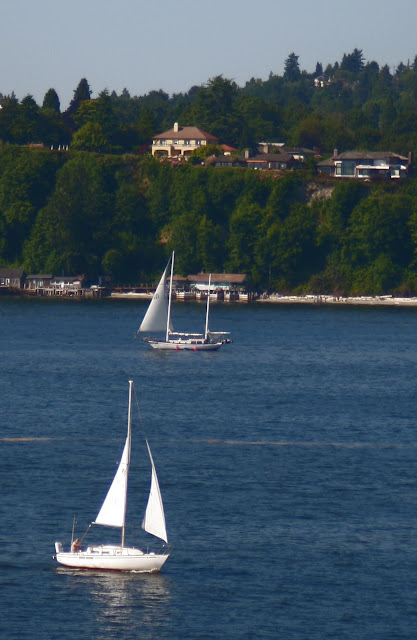
 Sailboats dotted Puget Sound as we left Seattle.

 Looking north toward more of Puget Sound.

 This sailboard came along-side us and the occupants were waving wildly to all the cruise ship passengers -- who, in turn, eagerly returned their waves!

A close up of the occupants of the sailboat in the previous photo.

 What beautiful scenery and sights as we sailed further north into Puget Sound's waters.

Another view of Seattle's northern metro area.  Lynette's Aunt Judy has a condo in that building just to the right of the sailboats docked (left).  We've visited Judy at this condo last year and I can tell you that she has absolutely spectacular views of Puget Sound and the shipping/boating traffic.

So, that's our departure from Seattle aboard the Golden Princess.  The rest of the evening and all of tomorrow we were at sea, cruising up the rest of Puget Sound, out the Strait of Juan de Fuca -- with the north coast of Washington State on our port side and Vancouver Island on our starboard side -- and then paralleling the seaboard side of Alaska's Inside Passage as we cruised north.  Next stop:  Ketchikan.


Wednesday, July 24, 2013

Grand Canyon of the Yellowstone River -- featuring spectacular waterfalls

Wednesday, 24 July 2013.  First of all, I want to wish my lovely wife, Lynette, a fantastic HAPPY ANNIVERSARY!  Four years ago today we were married -- for the second time, mind you -- on the beaches of North Carolina's Outer Banks in Kill Devil Hills.  The ceremony was very casual -- everyone was barefoot except me -- and witnesses included our two sons, two daughters-in-law, our four grandchildren, and a close family friend.  It was a simple, but beautiful ceremony and our grandkids were full participants.  Whether scattering rose petals on the sand for Grandma to walk on or carrying those precious rings (Good job, Ben!), these youngsters were up to the task.  And were they ever so gosh darn cute!  The picture of that moment will forever be etched in my mind.  Thanks for over 38 years together, Sweetheart! So looking forward to many, more more with you on our roaming travels!  XOXOXO

So our Yellowstone National Park visit now comes to an end.  I sincerely hope that someday we can return because the Park -- with all its beauty, both landscape and wildlife -- is simply one incredible national treasure.  We ended our Park visit with a half-day's sightseeing of the Grand Canyon of the Yellowstone River with its Upper and Lower Falls.  What spectacular scenery!  Thank goodness for digital photography! I took oodles of pics and just sorting thru them -- let alone editing the ones for this blog entry -- was a mighty task.  But I did what I needed to do -- hope you enjoy these few photos of the canyon, the falls and the Yellowstone River as much as we did sightseeing and taking photos.  Breathtaking, to say the least!


The Yellowstone River is the driving force that created the canyon and its waterfalls.  The river begins its journey 600-miles north just south of the park, ending its trip in North Dakota where it empties into the mighty Missouri River. The Yellowstone is the longest undammed river in the continental US.

By far, the primary geologic feature in the Park’s Canyon District is the roughly 20-mile long Grand Canyon of the Yellowstone.  The canyon as we know it today is a very recent geologic feature, not more than 10,000 to 14,000 years old, although there’s probably been a canyon in this area for a much longer period.

The two wateralls are formed by erosion as the Yellowstone River flows over progressively softer, less resistant rock. The Upper Falls is upstream from the Lower Falls and is 109-ft. high. The Lower Falls is 308-ft. high and can be seen from several viewing points along various trails. 

First glimpse of the Upper Falls.  Not many viewpoints for these falls; more for the Lower Falls.

Inspiration Point is a sightseeing area just south of the Lower Falls, with spectacular views of this waterfall. This wayside also had this very nice map of the area and I'm including it in the blog to give our readers a feel for how we went about our sightseeing visit here.  We drove south from Canyon Village (where we spent some time shopping and had a bite to eat for lunch) and picked up the North Rim Road; we didn't go to the other side of the Yellowstone River, so all the pics are shots from the North Rim side).  We continued to follow the North Rim Road to its end, stopping at various sightseeing places along the way.  BTW: The roads were excellent throughout the Park -- kudos to the Park Service!


Lynette posing with a sign that provided some basic info on the canyon.

 First glimpse of the Lower Falls.

Closer view of the spectacular -- almost breathtaking -- Lower Falls!

 Looking at one of the Lower Falls viewing platforms.  I shot this with my telefoto lens and this actual platform was a good mile away.  Going down wouldn't have been so bad -- it would have been the going back up.  So, we didn't take the walk down but still got some great shots.

A look across the river, looking at the MANY steps from the South Rim Road that will take you down to the river's edge for a great view of the Lower Falls.  I'm sure those folks got some great pics, but man, what a long walk back to the top!

Taking a brief respite against a tree on one of the trails off the North Rim Road leading to photo opportunities of the Lower Falls and the Yellowstone River as it flows north through the canyon. 

The Yellowstone River flowing north just after plunging over the Lower Falls.

 Another shot of the river as it flow north into the canyon.

The following pics are the "best" of my Lower Falls shots.  These falls are just absolutely spectacular to view and both Lynette and I thoroughly enjoyed our all-too-brief stop in this part of Yellowstone.

 And, yes, that is still SNOW on the side of the river.  Amazing!

 What a view -- and probably fighter-jet loud noise -- these thrill seekers must be getting!


Lynette posing on one of the viewing platforms with the Lower Falls in the distance.

Same viewing platform as previous pic, but with some handsome dude in the photo!

This is a pretty good shot showing the impressive Grand Canyon of the Yellowstone as its namesake river continues its 600-mile journey north toward its ending at the Missouri River.  

This blog entry concludes our visit to Yellowstone National Park.  As I've said several times -- both on Facebook and in this blog -- the Park is truly a national treasure.  I certainly hope every American gets to visit and enjoy this magnificent wonder of nature.  But now, it's time for other adventures.  Next up:  Our cruise to Alaska's Inside Passage that we enjoyed with Lynette's parents to celebrate their 65th wedding anniversary.  To say we all thoroughly enjoyed this adventure would be a vast understatement.  I'm looking forward to putting together most likely several blog entries to document our time aboard the Golden Princess and ashore during our excursions!  See ya' soon!


Tuesday, July 23, 2013

Geysers, mudpots, and hot springs -- and, of course, Old Faithful!

Tuesday, 23 July 2013.  Before tackling Yellowstone's "thermal" side, let's take a quick look at some of the Park's history.  Yellowstone National Park was established by Congress in March 1872, making it not only the first national park in the US, but in the world.  Known for its abundant wildlife and its many geothermal features, it is one of our most popular national parks. While Native Americans have lived in the Yellowstone area for at least 11,000 years, this region was bypassed by Lewis and Clark during their expedition. Aside from visits by mountain men during the early-to-mid-19th century, organized exploration did not begin until the late 1860's. The U.S. Army was actually commissioned to oversee the park and it wasn’t until 1917 that the National Park Service -- created the previous year -- took over administration of Yellowstone. Hundreds of structures have been built over the years and are protected for their architectural and historical significance, and researchers have examined more than 1,000 archaeological sites.

Yellowstone Park spans almost 3,500 sq/miles comprising lakes, canyons, rivers and mountain ranges -- and the vast majority of the Park's land is considered a wilderness region. Yellowstone Lake is one of the largest high-altitude lakes in North America and is centered over the Yellowstone Caldera, the largest supervolcano on the continent. The caldera is considered an active volcano and has erupted with tremendous force several times in the last two million years.  Half the world's geothermal features are in Yellowstone, fueled by this ongoing volcanic activity. Lava flows and rocks from volcanic eruptions cover most of the land area of Yellowstone and the Park is the centerpiece of the Greater Yellowstone Ecosystem, the largest remaining, nearly intact ecosystem in the Earth's northern temperate zone.

Hundreds of species of mammals, birds, fish and reptiles have been documented throughout the Park, including several that are either endangered or threatened. Grizzly bears, wolves, and free-ranging herds of bison and elk live and thrive in the Park, and Yellowstone’s bison herd is the oldest and largest public bison herd in the US. Yellowstone Park is also the largest and most famous megafauna location in the Continental US and the Park's vast forests and grasslands include many unique species of plants.  Forest fires are natural events and occur in the park each year; in the large forest fires of 1988, nearly one third of the park was burnt. We saw many information signs along the Parks's roadsides letting us know that this part of Yellowstone's forests had been naturally reseeded thru forest fires. Yellowstone National Park has numerous recreational opportunities, including hiking, camping, boating, fishing and sightseeing.  And while paved roads provide close access to the major geothermal areas as well as some of the lakes and waterfalls, actually less than 2% of Yellowstone is considered developed.  The remainder is left as wilderness.

Yellowstone has been designated a US Biosphere Reserve -- a World Heritage Site -- and protects over 10,000 geysers, hot springs, mud pots and steam vents – the earth’s largest array of geothermal features.

Celestine Pool, one of the most beautiful hot springs on the Fountain Paint Pot Nature Trail. 

The following three pics depict the steam vents of Roaring Mountain (8,100-ft), named for the numerous fumaroles on the western slope of the peak.


 Saw numerous caution signs such as this throughout the Park -- a word to the wise. 

 One of a number of "hot" lakes, warmed by numerous hot springs.

Notice all the dead and dying trees surrounding this "hot" lake; must be something in the water!

The next few slides were taken at Norris Geyser Basin, which is one of Yellowstone’s prime hydrothermal areas.  Found on the west side of the park, it sits several miles north of Old Faithful..


Notice the monitor of some kind on the dead tree branch. We smelled what seemed to us lots and lots of sulfur odors throughout this whole area.

The following two signs -- displayed along the walkways of Porcelain Basin Trail (part of Norris Geyser Basin) -- told us we were obey the Park's rules and regulations.


Here's more pics of Porcelain Basin Trail.


The following two pics from Norris Geyser Basin depict Ledge Geyser, the second largest geyser in the Norris Geyser Basin. While this geyser can shoot water up to 125-ft into the air, we only saw sprays of a few feet while we were there.  Impressive steam, though!


Another view of Norris Geyser Basin, showing what thermal activity does to the surrounding trees.

The following several pics show more of the impressive Porcelain Geyser Trail of the Norris Geyser Basin.


This was shallow flowing water with brilliant colors -- from the minerals, I guess.

Yep, that's bubbling water.  Hot bubbling water, I might add.


 The Ledge Geyser is just behind us -- just letting off some steam!


The following two pics are of Clepsdra Geyser. Shooting water up to 45-ft into the air almost continuously, Clepsydra is derived from the Greek word for water clock. Prior to the 1959 Yellowstone earthquake, it erupted regularly every three minutes.


Fountain Geyser -- part of the Lower Geyser Basin in Yellowstone -- was not erupting while we were there, but Park info said it could be very impressive.  Just looked like a big hole with steam coming out of it when we were there.  Oh well, can't win them all!


The next few photos depict Yellowstone's Red Spouter, which did not exist until April 17, 1959.  Shortly after midnight on that day, a major earthquake rocked Hebgen Lake, Montana, 25 miles northwest of where Red Spouter exists today.  Jolts ripped through Yellowstone – in the aftermath, Red Spouter was born. This thing just fascinated me -- I just stood there taking shot after shot.  Looked like boiling clay.


Fountain Paint Pot is a vat of bubbling mud that contains the perfect mix of ingredients to create mudpots: heat, gases, water, volcanic rock, minerals, acid and living microorganisms.  Heat-loving “thermophiles” consume some of the gases and help convert them into sulfuric acid.  The acid breaks down rock to form clay – clay that mixes with water in mudpots.   Fountain Paint Pot is named for the reds, yellows and browns of the mud in this area of the Park. The differing colors are derived from oxidation states of the iron in the mud. As with all hot springs, the heat in the caldera forces pressurized water up through the ground, which is than expelled. The rising gasses cause the bubbling action.

Fountain Paint Pot is part of the Park's Lower Geyser Basin region.


This pic shows what's happening all over the Park to the trees and shrubs that surround the hot lakes and springs.  The following photo shows what eventually happens over time.


Old Faithful

Old Faithful at its full height on the day we were there.  Not quite as spectacular as some days!

Before we left the East Coast to begin our journey west, my youngest grand-daughter, Rayne, asked me to be sure and take a photo of Old Faithful when we visited Yellowstone. Since I didn't want to disappoint her, I made extra sure we planned plenty of time to catch Old Faithful in action -- it erupts every 90-minutes or so.  Unfortunately, Old Faithful just wasn't itself -- or should I say, spectacular self -- the day we were there. We were mightily disappointed at the lack of a "huge" eruption, and, I'm sad to say, these are the best of the multiple shots I took.  Hope they fit the bill, Rayne!

 Nearing the 90-minute mark, Old Faithful begins some steam activity.

 Starting to see some water spurting out of Old Faithful.

 Tourists gathering to watch Old Faithful erupt.  The famous Old Faithful Inn is in the background.

 Gathering steam.....

 Gathering more steam.....

 Old Faithful now spewing water and steam all over the place.....

 View from behind the crowd at Old Faithful's doorstep.

 Almost at its maximum height.....

 Old Faithful in all its glory -- max height on this day.

And Old Faithful sputtering out.  But wait another 90-minutes or so, and back she'll come!

And for those who'd like to see Old Faithful in a more dynamic pic, here's one from the Park's archives.


We concluded our day's tour of Yellowstone's geysers, mudpots, and hot springs with an exit visit of the Mammoth Hot Springs (MHS), near the north entrance into the Park at Gardiner.  MHS features are quite different from thermal areas elsewhere in Yellowstone. Travertine formations grow much more rapidly than sinter formations due to the softer nature of limestone. As hot water rises through limestone, large quantities of rock are dissolved by the hot water, and a white chalky mineral is deposited on the surface.


 This warning sign was enough to keep us on the walkways.

 Mammoth Hot Springs village can be seen in the background.  MHS also served as the Park's original headquarters when the US Army built Fort Yellowstone here.  Many of the Fort's original buildings and structures now serve as tourist or administrative functions for the Park.


 I called this MHS formation "Elephant Rock."  Anybody else see the resemblance?

 A closer view of "Elephant Rock"

 Another view of "Elephant Rock."  See, it does look like Dumbo lying down!

 A side view of Dumbo.

So, that concludes the blog entry for Yellowstone's thermal attractions.  One more blog entry -- this one featuring the Grand Canyon of Yellowstone and its Upper and Lower waterfalls -- will conclude the Yellowstone adventure.  Then its on to Alaska!