
Today, Astoria (pop. ~10,000) is a charming, artsy little town situated
mostly on a hill overlooking the mighty Columbia River just a few miles from
where the river flows into the Pacific Ocean.
Lining the south banks of the Columbia, Astoria is surrounded by water
and tall evergreen Douglas fir, hemlock and spruce trees. The city is rich in
scenic beauty, with a vista of the Pacific Ocean and endless miles of beautiful sandy
beaches. We thoroughly enjoyed our time here and has "short-listed" it as a place we'd like to visit again.

View of Astoria from the top of its hill overlooking the Columbia River. The 4-mile long Astoria–Megler
Bridge, which connects Astoria with Washington State, can be seen at the top right of this photo.
Astoria is named after John
Jacob Astor whose American Fur Company (AFC) founded Fort Astoria here in 1811. As well as becoming AFC's primary fur-trading post in the Northwest, the Fort turned out to be an
extremely important post for American exploration of the continent and was
influential in establishing American claims to this land. The Lewis and Clark Expedition (Corps of Engineers) spent the
winter of 1805–1806 at Fort Clatsop, a small log structure SW of modern-day
Astoria. The expedition had hoped a ship would come by to take them back east,
but instead endured a torturous winter of rain and cold, and then returned east
the way they came. Today the fort has been recreated and is now a national
monument.
Astoria attracted a host of immigrants beginning in the late
19th century: Nordic settlers (primarily Finns), and Chinese soon became
significant parts of the population. The Finns took most of the fishing jobs and
lived primarily near the present-day end of the Astoria–Megler Bridge, which connects
the city – and Oregon -- to neighboring Washington State across the Columbia
River. The Chinese tended to do cannery
work, and usually lived either downtown or in bunkhouses near the canneries. In
1883 -- and again in 1922 -- downtown Astoria was devastated by fire, partly
because it was mostly wood and entirely raised off the marshy ground on
pilings. Even after the first fire, the same format was used in rebuilding the town, and the second
time around the flames spread quickly again, as collapsing streets took out the
water system. Frantic citizens resorted to dynamite, blowing up entire
buildings to stop the fire from going further.
Between 1921 and 1966, a ferry route across the Columbia
River connected Astoria with Washington State. In 1966 the Astoria–Megler Bridge was opened,
completing US Route 101 across the river to the Evergreen State. Today, tourism,
Astoria's growing art scene, and light manufacturing are the main economic
activities of this very charming city.
One last piece of trivia: Astoria is tied with Lake Charles,
LA, and Port Arthur, TX, as the most humid city in the contiguous US. Average relative humidity in Astoria is 89%
in the morning and 73% in the afternoon.
Thank goodness for those Pacific Ocean breezes!

A view from a beach at Fort Stevens State Park, just a couple miles outside of Astoria, looking north toward Cape Disappointment in Washington State. Lots and lots of driftwood for that beach campfire!
.jpg)
This is a blow-up of the previous pic. Wanted to point out Cape Disappointment Lighthouse on the Washington State side of the Columbia (upper middle of photo, on the bluff overlooking the water. Great vantage point for photo-ops, which you'll see later in this blog.

Hull remains of the sailing ship Peter Iredale -- found on one of the beaches at Fort Stevens State Park.

Here's a couple more pics of what remains of the Peter Iredale's hull. We spent about an hour at this beach and the whole time we were there kids were playing all around this hull wreck...doing what kids do.


In addition to the shipwreck, we also hiked up to what remains of the gun emplacements at Fort Stevens. This fort was once the primary military defense installation in a three-fort, Harbor Defense System at the mouth of the Columbia River (Forts Canby and Columbia in Washington were the other two). Fort Stevens was in service for 84 years, beginning with the Civil War and closing at the end of World War II. Today, Fort Stevens has grown into a 4,200 acre park/beach. Here's just a few pics from our visit there.


A view from Fort Stevens State Park, looking across the Columbia at Cape Disappointment; the lighthouse in this pic is the oldest
lighthouse on the northwest coast of the USA, Cape Disappointment Lighthouse, marking
the north side of the Columbia River Bar (more on this later). We actually drove over to Cape Disappointment one day and hiked up to the lighthouse. Quite a hike, let me tell you!

Another view from Fort Stevens State Park looking east toward the Astoria-Megler Bridge.

A tug pulling a barge up the Columbia River toward Astoria.

A view of the breakers roaring toward a beach at Fort Stevens State Park. Took this pic from a platform the Park had erected on the South Jetty for viewing passing ships going up-down the Columbia and also for whale watching. We saw no whales while we were there. Great spot to watch ships, though.

A telefoto lens view of the Cape Disappointment Lighthouse.

Another pic taken from the South Jetty viewing platform. You can see one of those passing ships I mentioned in the distance.

Fort Clatsop was the winter encampment for the Lewis & Clark Corps of Discovery from December 1805 to March 1806. Lewis and Clark National Historic Park, just a few miles SW of Astoria features a wonderful visitor center that includes a replica of Fort Clatsop similar to the one built by the explorers.

Drawing of what Fort Clatsop might have like....and the replica today (below pic).

While we were at the Fort Clatsop, we were treated to a short lecture and demo of one type of flintlock musket used by the Lewis and Clark expedition. What follows are several pics during that demo, including a series of three pics I'm quite proud of. After showing us how to load and pack the musket, the Park Ranger then fired a shot off into the woods. Think I ended up with some great shots!

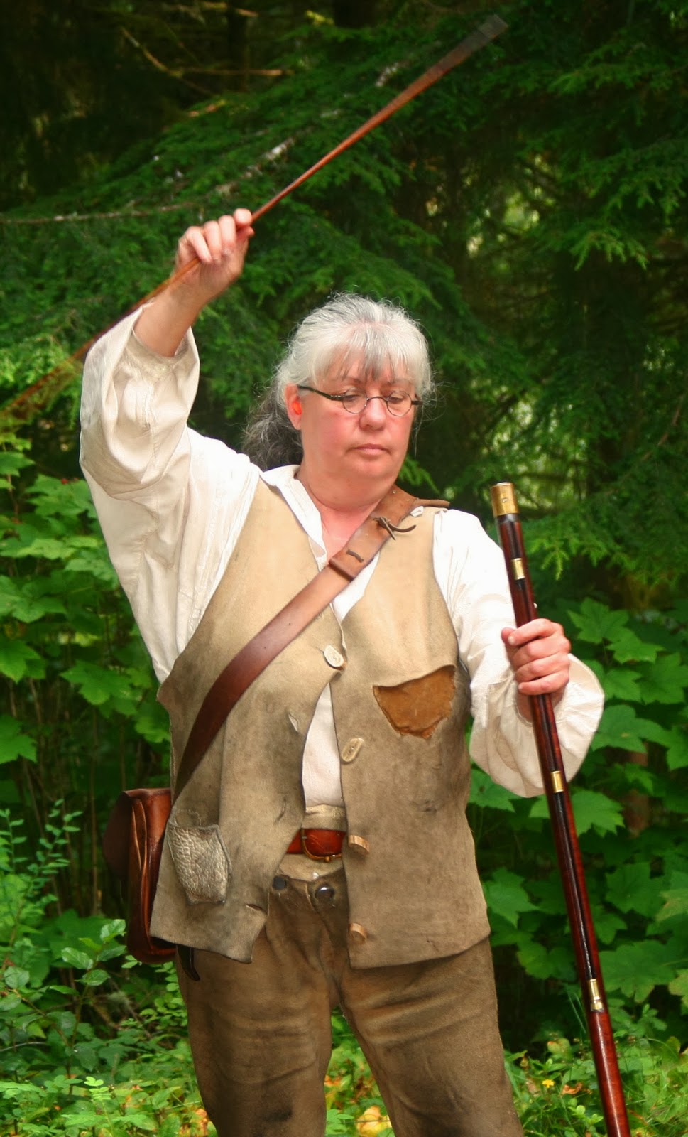


The exact moment the Ranger pulled the trigger.....

.....and right after the shot was fired. Notice the sparks out in front of the musket.

One last pic taken a second later. Pretty neat!

Replica of a dugout canoe used by the Lewis and Clark expedition while at Fort Clatsop.

A long-deserted boat landing area on the Lewis and Clark River, a few hundred yards from the Fort.

Lynette posing next to a bronze statue of Sacagawea and her papoose, a few yards from the visitor center.
Located on Astoria's historic waterfront sets the acclaimed
Columbia River Maritime Museum that has one of the most
extensive collections of nautical artifacts on the west coast. Designated Oregon's official state maritime
museum, this place has 24,000-sq/ft. feet of exhibit space and was the first nationally accredited maritime museum in the western US. The museum is one of the country's finest
displays about shipwrecks, lighthouses, fishing, navigation and naval history. A must see if visiting Astoria.

A view of the museum at dusk. Very modern architecture, yes?

Me posing with a propeller that sat next to the museum entrance.

And me with an anchor just outside the museum; Coast Guard cutter in the background.

Snapped this pic inside the museum; part of an exhibit describing the dangerous ocean waves in this area.

Another display board inside the museum showing the known ships lost to these dangerous waters. This map shows the North Jetty, Cape Disappointment, and Sand Island (on the Washington State side of the Columbia), and the South Jetty (on the southern, or Oregon side).

A shot of a life-sized Coast Guard rescue display inside the museum. This display was pretty impressive.

Several of the life-sized displays in the museum depicted Astoria's fishing industry.

Saw these birds on the water just outside the museum entrance; thought it made for a nice photo-op.

A USCG cutter on display near the museum. For a small fee, you could tour the boat.

Another photo-op: View of Astoria's main street near the waterfront area with a logging truck making its way thru town. One can see how steep the streets are as they climb up from the waterfront.
One of the reasons for coming to Astoria -- in addition to sightseeing -- was for Lynette to do some genealogical research on her ancestors. She knew there was a woman who came north from California to Astoria and married a local man -- who turned out to be quite wealthy. After some brief research (she was looking for a photo, but no luck) we did locate the home they lived in. Here's a shot of it; quite beautiful if you ask me. One can see some scaffolding to the right of the home; doing some minor repairs, I guess.

Although I grew up in the Evergreen State, there is much of Washington I've never seen. One spot I'd always wanted to visit was Cape Disappointment, a large headland located at the
extreme SW corner of the state, on the north side of the Columbia River Bar
(CRB). The Cape forms the northern
portion of the mouth of the Columbia River as it opens to the Pacific Ocean.
The following map shows in pretty good detail much of what I've included in this blog entry. To give you an idea of scale, the Astoria-Megler Bridge (noted as just the Astoria Bridge on this map) -- that connects Astoria with Washington State -- is four miles in length. Gives you an idea of how wide the Columbia is as it empties into the Pacific Ocean. On the Washington side the map shows Cape Disappointment and on the Oregon side, Fort Stevens State Park. When we decided to do some sightseeing at the Cape, we drove across the bridge and followed Route 101 through the small town of Chinook, down to Iwaco, and then on to Cape Disappointment State Park. There are some magnificent views of the Pacific Ocean, the Columbia River and Bar, and the Oregon Coast looking south. And as you'll soon see, also some of the breakers in the Columbia River as they break over the Columbia River Bar -- part of what makes these such dangerous waters for shipping and boating.

The area in-and-around the Cape is regarded
as some of the most dangerous stretch of waters anywhere, and the Columbia River Bar (CRB) is one of the most treacherous river bars in the world. Because of the large number of shipwrecks (since
1792 about 2,000 large ships have sunk in-and-around the CRB) near the river
entrance, it has justly earned the nickname, “The Graveyard of the Pacific.” During winter storms, wind-driven ocean swells
often reach a height of 20-30-ft. at the entrance of the bar. With the
combination of strong outgoing Columbia River tides and large incoming swells,
large surf conditions can exist at the bar entrance. The CRB is actually a
system of bars and shoals at the mouth of the Columbia; it is about 3 miles wide
and 6 miles long. The bar is where the river's current dissipates into the
Pacific Ocean, often as large standing waves. The waves are partially caused by
the deposition of sediment as the river slows, as well as mixing with ocean
waves. The waves, wind, and current are extremely hazardous for ships/boats of
all sizes. Unlike other major rivers, the Columbia’s current is focused
"like a giant fire hose" without the benefit of a river delta.
Conditions can change from calm to life-threatening in as little as five
minutes due to changes in direction of wind and ocean swell. At any one time,
about 16 bar pilots (earning about $180K per year) guide ships across the bar,
often boarding ships by helicopter.

Another map clearly showing the North Jetty and South Jetty. The following series of pics were taken from various viewpoints on Cape Disappointment.
Our first stop was the North Head Lighthouse in Cape Disappointment State Park in Washington State. The lighthouse no longer has public access , but sure serves as a excellent spot for some great photo-ops.

Snapped this pic on the walk up to the North Head Lighthouse. This is looking south toward Oregon.

This pic -- and the following ones -- also looks south, and shows the North Jetty (in foreground) and the South Jetty in the distance on the Oregon side of the Columbia River.


This shot shows some of the breakers as they pass over the Columbia River Bar. That beach in the background in on Fort Stevens State Park.
.jpg)
The is a blow-up of the above pic, showing that beach and in the middle of the photo, the wooden platform (looks like a squatty "T") that I described earlier; platform sits on the South Jetty.

Looking east, back toward Astoria (upper right of photo). You can just make out the Astoria-Megler Bridge. Washington State is left, Oregon on the right.

Astoria in the distance.

The Astoria-Megler Bridge in the distance with a Coast Guard boat headed out into the CRB.
.jpg)
A nice shot of those breakers on the bar.

View as you approach the North Head Lighthouse on Cape Disappointment.

Another view of the North Head Lighthouse.
Here's some history of the North Head Lighthouse.


Plaque on the side of the lighthouse marking its exact location.

Lynette posing in front of the North Head Lighthouse. Yes, it was windy up there!

Snapped this pic of Lynette on our way down the trail from the North Head Lighthouse. That's the South Jetty in the distance (Oregon side) jutting out into the Pacific Ocean.
US Coast Guard (USCG) Station Cape Disappointment -- situated
nearby at the mouth of the Columbia River -- is renowned for operating in some of
the roughest sea conditions in the world. The Station is also home to the National Motor
Lifeboat School (NMLS), the
only school for rough weather and surf rescue operations in the US; it is
respected internationally as a center of excellence for heavy boat operations.
The Station is the largest USCG search and rescue (SAR) station on the Pacific Northwest
Coast, with 50 crewmembers assigned. The Station has nine SAR boats, including
a 52-ft Triumph class motor lifeboat, six 47-ft motor lifeboats, and two 25-ft
Defender class response boats. The 52'- Triumph class and 47' motor lifeboats
are designed to operate in heavy surf conditions and are capable of being rolled
over by breaking swells and then re-right themselves with minimal damage. Station personnel regularly train in the surf
at Cape Disappointment and the large surf conditions at the bar entrance. Check out the following pics.


To view a really neat video of the USCG surf training on the CRB, go to their Facebook homepage at: https://www.facebook.com/USCoastGuardStationCapeDisappointment

Here's a pic of the actual US Coast Guard Station Cape Disappointment.
Co-located with the Coast Guard Station is the oldest lighthouse on the
northwest coast of the US, Cape Disappointment Lighthouse, marking the north side of
the Columbia River Bar (CRB). Less than two miles to the NW lies the North Head Lighthouse, which provides a
beacon for northern approaches to the CRB.
I shot the following pics from the Cape Disappointment Lighthouse.

Lynette, posing in front of the Cape Disappointment Lighthouse. Apologize for the quality of the pic; I had to shoot straight into the setting sun.

Another shot of the lighthouse, using some shade this time!

Looking down into a cove just below the lighthouse.

Another view from the lighthouse vantage point.

Looking south from the lighthouse, with the North Jetty in the foreground, and the South Jetty (on the Oregon side of the Columbia) in the distance.

Took this shot on our loooooooong hike up to the lighthouse. The lighthouse sits at the top of the outcropping at the left center of this pic.

View of a small cove on our hike up to the lighthouse.